A detailed description and study of the 2010 eruption of Nyamulagira is available in:
Smets B., d’Oreye N., Kervyn F., Kervyn M., Albino F., Arellano S.R., Bagalwa M., Balagizi C., Carn S.A., Darrah T.H., Fernández J., Galle B., González P.J., Head E., Karume K., Kavotha D., Lukaya F., Mashagiro N., Mavonga G., Norman P., Osodundu E., Pallero J.L.G., Prieto J.F., Samsonov S., Syauswa M., Tedesco D., Tiampo K., Wauthier C., Yalire M.M., 2014. Detailed multidisciplinary monitoring reveals pre- and co-eruptive signals at Nyamulagira volcano (North Kivu, Democratic Republic of Congo). Bulletin of Volcanology 76 (1): 787, 35p. [Link]
Eruption reports
(Archives of the former website of the GORISK team)
– GORISK Eruption Report n°9 – 3rd February 2010
– GORISK Eruption Report n°8 – 23rd January 2010
– GORISK Eruption Report n°7 – 20th January 2010
– GORISK Eruption Report n°6 – 19th January 2010
– GORISK Eruption Report n°5 – 18th January 2010
– GORISK Eruption Report n°4 – 15th January 2010
– GORISK Eruption Report n°3 – 14th January 2010
– GORISK Eruption Report n°2 – 12th January 2010
– GORISK Eruption Report n°1 – 7th January 2010
(c) GORISK Scientific Network, 2010-2011
———-
GORISK Eruption Report n°9
“Nyamulagira eruption ended on January 27th 2010”
 The observations made during the last overflight achieved on January 27th indicated that no lava fountain nor lava flows were observed. Only fumarolic activity has been seen in the eruptive vent suggesting that the eruption has reach its end.
Those visual observations are also confirmed by a steep drop in the seismic activity recorded from January 27th 11 A.M. UTC (1 P.M. local time).
A team has walked to reach one of the lava flows to collect samples on 30th January.
———-
GORISK Eruption Report n°8
“Situation on 22nd and 23rd January 2010”

During last three days, the eruptive activity has decreased.
The lips of the eruptive cone are now joined and the cone contains a lava lake with small fountains. Seismic records show important tremors linked to this activity inside the cone. A channel drains the lava out from a small outlet at the base of the cone, on its southwestern flank.
Since the 22nd January, the eastwards lava flow has stopped ~5 km far from the vent. The channel now feeds a small flow moving southwards, following the same path as the most western flows.
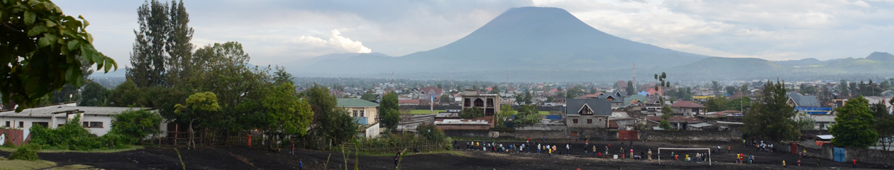
The current activity doesn’t threaten neighbouring population and infrastructure. Only the Virunga National Park remains affected.
———-
GORISK Eruption Report n°7
“Situation on 20th January 2010”

Lava fountains at the eruptive fracture are still active and restricted to the upper part of the cone. Lava flows that moved towards South and South-West are stopped and the active lava channel feeds now a new small lava flow that moves towards East. This new lava flow has grown by 750 m in two days.
Lava flows still not threaten road or inhabited area.
———-
GORISK Eruption Report n°6
“Situation on 19th January 2010”
The eruptive fissure South-East of the caldera remains active as it was in the last few days. Moderate to small lava fountains (from few tenths to ~ hundreds meters high) eject now lower volumes of lava compared to a week ago. Only one extremely small lava flow was moving towards the south-west flank of the volcano. The lava flow, firstly detected last week-end seems to have traveled only ~400 m in the last two days and it looks poorly fed.
Although the lava fountains are still present, their intensity, height and volumes are slowly decreasing.
All lava fronts seem not to progress and at least two of them, those at 10,5 Km from the eruptive fracture, have completely stopped few days ago. The treat to the road Goma -Sake, the major road axe of the area, is mostly over with the activity recorded in the last days.
———-
GORISK Eruption Report n°5
“Situation on 16th and 17th January 2010”

The East and West lava flows didn’t move further. Less smoke in local and isolated places.
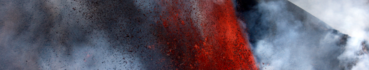
A new lava flow was identified flowing towards South-West produced from the same eruptive vent. Red fresh lava is clearly visible at the new lava flow front. The length of this new lava flow was about 4.5 km in the morning of the 17th January. This lava flow is only a threat for the forest of the Virunga National Park.
The height of lava fountains remains identic to previous days. They are focused in the eruptive vent and still reach heights of about 100 m. The eruptive cone is still growing up.
No activity was observed inside the caldera itself.
———-
GORISK Eruption Report n°4
“Situation on 15th January 2010”
The volcanic activity of Nyamulagira seems to decrease. The rate of flow in the active lava channel is weaker and seems to end in small lava flows covering previous lava flows (see photo below) .


———-
GORISK Eruption Report n°3
“Situation on 13th January 2010”

The height of lava fountains at the eruptive site is similar to previous days, i.e. 50 to up to 100 meters high. The new spatter cone still grows and the lava channel that escapes from it becomes less incandescent than previous days.
Two lava flows flow toward the South. The western lava flow seems to be stationary since the beginning of this week. The eastern lava flow seems to slow down with only 200 m traveled between the 12th and the 13th January.
No eruptive activity is visible in the central caldera of Nyamulagira.
———-
GORISK Eruption Report n°2
“Situation on 12th January 2010”
On 12th January, lava fountains are higher than the day before and their intensity is less constant than previous days. Their maximum heights is about 150 meters high. According to our GPS measurements, the eastern lava flow traveled approximately 650 m since the 11th January. The western lava flow seems to be stopped since the week-end. No activity is visible in the caldera.

———-
GORISK Eruption Report n°1
“2nd January 2010, ERUPTION OF NYAMULAGIRA”
Mount Nyamulagira, one of the most active volcano in Africa, erupted on 2nd January at 1:07am (local time, UTC+2).
The eruption is located in the main crater, a 2 x 2,3 km caldera, and along a fracture on the south-eastern flank of the volcano. The eruptive activity corresponds to lava fountains, gas and ash plume, and lava flows. No precursor signs were observed before the eruption.
The first days of the eruption, a small lava lake with lava fountains appeared in the pit crater located north-east in the caldera and a lava flow covered the south and south-western part of the caldera. On the south-eastern flank of Nyamulagira, a ~200 m long wall of lava fountains has appeared and lava flows have flown towards the South in two branches (the western lava flow and the eastern lava flow). After few days, a spatter cone has been created on the eruptive fracture south-east of the caldera and the eruptive activity has been concentrated in this cone, still feeding the lava flows that travel toward the South.