Page Content
- Volcanic Edifice and Lava Field
- Magma Plumbing System
- Eruptive Activity
- Current Eruptive Activity
- Cited References
_______________________________
1. Volcanic Edifice and Lava Field
Nyamulagira (or Nyamuragira, 3058 m a.s.l.) is a shield volcano located in the western end of the Virunga volcanic province (North Kivu, D.R. Congo), in the rift depression. Its summit is shaped by a 2 x 2.3 km caldera. More than 100 adventive cones are scattered along its flanks and in the lava plain at its base.
In the western part of the VVP, eruptive cones NW and SE of Nyamulagira tend to align sub-parallel to the main rift escarpment in this area, in a NE-SW orientation, but the majority of cones and fissures of Nyiragongo and Nyamulagira is concentrated along a NNW-SSE-oriented weakness zone, which crosses both volcanoes. This NNW-SSE alignment of cones and eruptive fissures is inferred as the trace at the ground surface of a deep inherited basement structure (Pouclet, 1976; Smets et al., 2010) and/or the result of the local stress field resulting from the interaction of the gravitational loading of both Nyiragongo and Nyamulagira (Wauthier et al., 2012). In addition, lots of these cones are preferentially located at break-of-slopes, highlighting an influence of the gravitational stress field associated with the presence of the main volcanic edifice (Smets et al., 2015).
The enclaves observed in Nyamulagira lavas suggest that the Nyamulagira lava field developed above non- or poorly metamorphosed detritic rocks, such as sandstones, quartzites, arkoses, clay and/or schists (Verhoogen, 1948; Denaeyer and van Wallendael, 1961; Pouclet and Villeneuve, 1972; Pouclet, 1973, 1974; Kampunzu et al., 1984). Such lithology is similar to some of the surrounding Precambrian rocks (e.g., Pasteels, 1956,1961; Buchstein et al., 1967; Rumvegeri, 1987; Fernandez-Alonso, 2007), but could also correspond to more recent Tertiary-Quaternary sediments that filled the rift depressions (Yamba, 1993). Indeed, at least north of the Nyamulagira lava field, the lavas covered recent sediments of an unknown thickness.
—
2. Magma Plumbing System
(Text modified from Smets et al., 2015)
Like for Nyiragongo, information on the magmatic system of Nyamulagira is relatively poor. The presence of a main edifice at least indicates the existence of crustal magmatic chamber(s). The presence of a shallow magma chamber has also been inferred from the caldera, according to Wadge and Burt (2011). The petrological analyses of Brousse et al. (1979, 1981), Caron et al. (1982) and Kampunuzu et al. (1984) on the 1976-1977, 1980 and 1981-1982 lavas suggest that crystallization in magma primarily occurred at a depth of 5-7 km. Head et al. (2011) examined olivine-hosted melt inclusion volatiles for the 1938, 1948, 1986 and 2006 eruptions, showing that gas entrapment occurred at a slightly shallower depth range of 3-5 km. Hamaguchi (1983) detected an aseismic zone between 3 and 7 km beneath the 1981-1982 eruption site, suggesting that this evidence was indicative of a magma reservoir at this depth range. The numerical modelling of ground deformation through InSAR suggests a magma reservoir at a depth range of 2-4 km for the 1996, 2002, 2004, 2006 and 2010 eruptions (Toombs and Wadge, 2012; Wauthier et al., 2013).
Magma storage inside the main edifice or within a vertical conduit is also likely, as suggested by the presence of a lava lake in the central caldera between the 1920s and 1938 (Verhoogen 1948), the markedly short-term seismic precursors prior to the 2010 eruption (Smets et al. 2014a), inter-eruptive ground deformation in the central caldera (Toombs and Wadge, 2012; Wauthier et al., 2013), and the more recent degassing, lava fountaining and lava lake activity in the pit crater of the central caldera (Campion, 2014; Smets et al. 2014b).
A low seismic velocity region detected at a depth of 20 to 30 km suggests the existence of another magmatic reservoir beneath the volcano (Mavonga et al., 2010). According to Chakrabarti et al. (2009), the depth of partial melting should approximate 80 km. Thus, Nyamulagira should have at least two main levels of magma storage between the primary source of magma and the ground surface.
—
3. Eruptive activity
(Text modified from Smets et al., 2015)
Nyamulagira erupted at least 42 times since the late 19th century, with an increase in eruption frequency in the last 30 years. These eruptions are characterized by lava fountains building up a pyroclastic cone around the vent, long lava flows able to reach tens of kilometers, together with the emission of very large amounts of SO2. Most eruptions take place along a NNW-SSE fracture network that crosses the main edifice.
Pouclet (1976) and Smets et al. (2014a) reported that Nyamulagira eruptions typically show a similar evolutionary pattern and occasionally occur with minor variations. Based on years of field observations and the interpretation of 21 historical eruptions, Pouclet (1976) conceptually distinguished two primary types of eruptive events: classical and major eruptions. Classical events are initiated in the caldera and/or on volcano flanks, with explosions and eruptive fissure(s) openings. The coexistence of summit and flank erupting vents was observed at least for the 1894, 1957, 1989, 1994, 2000, 2001, 2002, 2004 and 2010 eruptions (Pouclet, 1976; Smithsonian, 1971-2014; Kavotha, 1992; Smets et al., 2014a). In the first hours/days lava fountains, forming spatter ramparts along the fissure, ash-laden gas plumes with Pelee’s hairs, and fast moving (i.e., up to several kilometres per hour) lava flows are observed. The peak of eruption intensity is reached during this first stage. Next, the activity stabilizes and progressively becomes more effusive with a decreasing ash content in the emitted plume, the focusing of lava fountains into a smaller section of the eruptive fissure, and the transition from fast moving lava flows to lava thickening through flow stacking. When eruptions are initiated both on top and on the flank of the volcano, the summit effusion terminates at this stage, and the eruptive activity concentrates at the flank vent. Finally, the eruptive activity progressively decreases to an active lava pond nested inside the flank vent. Fumarole activity persists after the eruptions terminate. During flank eruptions, and less frequently in the caldera, spatter-to-scoria cones are produced along the eruptive fissures. These classical eruptions of Nyamulagira last from a few days to a few weeks with an average of approximately 20 to 30 days. The typical erupted lava volume of flank eruptions is 40 to 70 × 106 m3, but this volume could be much smaller during summit eruptions (Table 2). These values are relatively standard for a basaltic volcano (Siebert et al., 2010).
Less frequently, i.e., every ~10 years since 1940, major eruptions occur. These events emit much larger volumes of lava (i.e., > 80 × 106 m3), often last longer (i.e., several months to years) and typically show more complex characteristics, with the growth of several large pyroclastic cones along multiple fissure segments, the renewal of fountaining activity during an intermediate stage of the eruption and occasionally, local co-eruptive earthquakes (e.g., Tack, 1982). The most long-lived eruptions typically occur in the lava plain, kilometres from the central caldera.
This eruptive activity, mostly characterized by flank eruptions, was interrupted by intracrateral eruptive activity between 1913 and 1938. Reports of a red glow at the top of Nyamulagira suggest potential episodic eruptive activity in the caldera starting since 1913 (Pouclet, 1976). There is evidence for a lava lake in the Nyamulagira caldera from at least 1929 to 1938 (Hoier, 1939; Verhoogen, 1939,1948; Gevers, 1940). The Nyamulagira lava lake was located in a pit crater, in the NE part of the central caldera. Between 1929 and 1938, this lava lake regularly fed a large depression in the SW part of the caldera, with lava escaping from fissures or lava lake overflow. Progressively, the lava lake level rose and the SW depression became almost completely filled with lava. In November 1936, a spatter cone developed over the lava lake, and in 1937, the lava invaded a large part of the caldera, forming hornitos in some areas (Hoier, 1939). In January 1938, a huge collapse of the western part of the caldera marked the beginning of a voluminous (> 200 × 106 m3 of lava) and very long (2.5 years) eruption. This eruption drained the lava lake and modified both the shape of the main edifice and the eruption style of the volcano, which came back to a flank eruption style (Verhoogen, 1948; Pouclet, 1976).
Such interruption of flank eruptive activity occurred another time, after the major 2011-2012 flank eruption. Since the end of that eruption, in April 2012, the same pit crater that hosted the 1913-1938 intracrateral activity started emitting large amounts of volcanic gases. In April 2014 and starting from June 2014, lava fountaining activity appeared in the pit crater. This activity in the central caldera progressively gave birth to the current semi-permanent lava lake.
The repetition of such a scenario today would mark a major change in the Nyamulagira eruption style. The potential consequences on the neighboring and less-remote Nyiragongo volcano remain unknown, as some (but not all) major flank eruptions of Nyamulagira may have triggered activity at Nyiragongo in the past.
—
4. Current eruptive activity
In April 2014 and from 23rd June to mid-September 2014, lava fountains appeared in the pit crater located in the NE part of the Nyamulagira’s main caldera (Smets et al., 2014b).
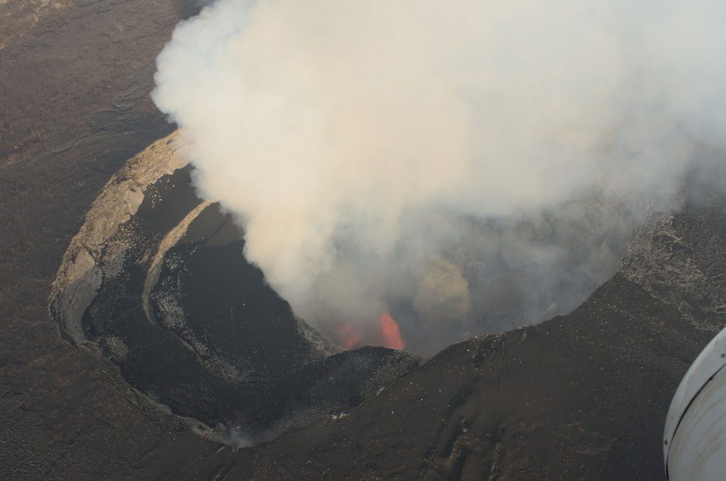
On 1st November 2014, this activity resumed in the form of a small persistent lava lake. This lava lake activity stopped around May 2016, but a thick gas plume still escapes from the pit crater.
More information about the recent eruptive activity of Nyamulagira is available in the Current Activity page.
—
5. Cited references
Brousse, R., Cocheme, J.-J., Pottier, Y., Vellutini, P.-J., 1979. Eruption et nature de la lave du Murara : un nouveau volcan (décembre 1976-avril 1977), au Kivu (Zaïre). Comptes Rendus de l’Académie des Sciences de Paris, Série D 289: 809–812.
Brousse, R., Caron, J.-P., Kampunzu, A.B., Lubala, R.T., Musengie, M.K., Vellutini, P.-J., 1981. Eruption et nature de la lave du Gasenyi: un nouveau volcan (janvier–février 1980) au flanc Nord du Nyamulagira (Kivu, Zaïre). Comptes Rendus de l’Académie des Sciences de Paris, Série II 292: 1413–1416.
Buchstein, M., Pelletier, J.L., Trottereau, G., 1967. Reconnaissance géologique et minière à l’Ouest de Bobandana (Nord-Kivu). Report Kin 72_17, Mission Minière Française auprès de la R.D.C., 48 pp.
Caron, J.P.H., Kampunzu, A.B., Lubala, R.T., Miruho, K.B., Musengie, M.K., Vellutini, P.J., Brousse, R., 1982. A propos de l’éruption adventive du Nyamuragira de janvier-février 1980 : Nature de la lave du nouveau Gasenyi. Annales de la Société Géologique de Belgique 105: 31–40.
Chakrabarti, R., Basu, A.R., Santo, A.P., Tedesco, D., Vaselli, O., 2009. Isotopic and geochemical evidence for a heterogeneous mantle plume origin of the Virunga volcanics, Western rift, East African Rift system. Chemical Geology 259: 273–289.
Denaeyer, M.E., Van Wallendael, M., 1961. Les enclaves énallogènes du Nyiragongo et du Nyamurgira (Kivu). Bulletin des Séances de l“Académie Royale des Sciences d”Outre-Mer N.S. VII: 460–467.
Fernandez-Alonso, M., 2007. Geological Map of the Mesoproterozoic Northeastern Kibara Belt. Royal Museum for Central Africa, Tervuren (Belgium), ISBN 978-90-74752-12-1.
Gevers, T.W., 1940. The 1938-1939 Eruption of Nyamlagira Volcano in the Kivu District of the Belgian Congo. Transactions of the Geological Society of South Africa 43, 109–126.
Hamaguchi, H., 1983. Seismological evidence for magma intrusion during the 1981-1982 Nyamuragira eruption. In: Hamaguchi, H. (Ed.), Volcanoes Nyiragongo and Nyamuragira: Geophysical aspects. The Faculty of Science, Tôhoku University, Sendai, Japan, pp. 35-42.
Head, E., Shaw, A.M., Wallace, P.J., Sims, K.W.W., Carn, S.A., 2011. Insight into volatile behavior at Nyamuragira volcano (D.R. Congo, Africa) through olivine-hosted melt inclusions. Geochem. Geophys. Geosyst. 12, Q0AB11.
Hoier, R., 1939. Contribution à l’étude de la morphologie du volcan Nyamuragira. Exploration du Parc National Albert, Institut des Parcs Nationaux du Congo belge, 37 pp.
Kampunzu, A.B., Lubala, R.T., Brousse, R., Caron, J.P.H., Cluzel, D., Lenoble, L., Vellutini, P.J., 1984. Sur l’éruption du Nyamulagira de décembre 1981 à janvier 1982: cône et coulée du Rugarambiro (Kivu, Zaïre). Bull Volcanol 47: 79–103.
Kavotha, K.S., 1992. Frequency Characteristics of the Volcanic Tremors Associated with the 1989 Nyamuragira Eruption. In Hamaguchi, H. (Ed.), Geophysical Study on the Hotspot Volcanoes in the African Continent. The Faculty of Science, Tôhoku University, Sendai, Japan, pp. 73–81.
Mavonga, T., Zana, N., Durrheim, R.J., 2010. Studies of crustal structure, seismic precursors to volcanic eruptions and earthquake hazard in the eastern provinces of the Democratic Republic of Congo. Journal of African Earth Sciences 58: 623–633.
Pasteels, P., 1956. Géologie et pétrographie de la région de Kirotshe (Kivu). PhD Thesis, Université Libre de Bruxelles, Belgique.
Pasteels, P., 1961. Géologie et pétrographie de la région de Kirotshe. Mémoires de l’Académie royale des Sciences d’Outre-Mer in-8° 15, 73 pp.
Pouclet, A., 1973. L’éruption du Nyamuragira de maes à mai 1971, cône et coulées du Rugarama. IRSAC Publication spéciale 1: 1–16.
Pouclet, A., 1974. Pétrographie du Rugarama, dernier cône adventif du volcan Nyamuragira (1971)(Rift W.-africain). Bull Volcanol 38: 397–424.
Pouclet, A., 1976. Volcanologie du rift de l’Afrique Centrale. Le Nyamulagira dans les Virunga : essai de magmatologie du rift. PhD Thesis, Université de Paris-Sud, Centre d’Orsay, France, 597 pp.
Pouclet, A., Villeneuve, M., 1972. L’éruption du Rugarama (mars-mai 1971) au volcan Nyamuragira (Rép. Zaïre). Bull Volcanol 36: 200–221.
Rumvegeri, B.T., 1987. Le Précambrien de l’Ouest du Lac Kivu (Zaïre) et sa Place dans l’Evolution Géodynamique de l’Afrique Centrale et Orientale. PhD Thesis, Université de Lubumbashi, 315 pp.
Siebert, L., Simkin, T., Kimberly, P., 2010. Volcanoes of the World (3rd Edition). Smithsonian Institution, University of California Press, 558 pp.
Smets, B., Kervyn, M., Kervyn, F., d’Oreye, N., Wauthier, C., 2010a. New insights into eruptive activity and lava flow hazard at Nyamulagira volcano, D.R.C., from a new GIS-based lava flow map. AGU Fall Meeting 2010, San Francisco, U.S.A., V11C-228.
Smets, B., d’Oreye, N., Kervyn, F., Kervyn, M., Albino, F., Arellano, S., Bagalwa, M., Balagizi, C., Carn, S.A., Darrah, T.H., Fernández, J., Galle, B., González, P.J., Head, E., Karume, K., Kavotha, D., Lukaya, F., Mashagiro, N., Mavonga, G., Norman, P., Osodundu, E., Pallero, J.L.G., Prieto, J.F., Samsonov, S., Syauswa, M., Tedesco, D., Tiampo, K., Wauthier, C., Yalire, M.M., 2014a. Detailed multidisciplinary monitoring reveals pre- and co-eruptive signals at Nyamulagira volcano (North Kivu, Democratic Republic of Congo). Bull Volcanol 76 (787): 35 pp.
Smets, B., d’Oreye, N., Kervyn, F., 2014b. Toward another lava lake in the Virunga Volcanic Field? EOS Transactions 95 (42): 377-378.
Smets, B., Kervyn, M., Kervyn, F., d’Oreye, N., 2015. Spatio-temporal dynamics of eruptions in a youthful extensional setting: Insights from Nyamulagira volcano (D.R. Congo), in the western branch of the East African Rift. Earth-Science Review 150, 305 – 328. doi:10.1016/j.earscirev.2015.08.008
Smithsonian Institution, 1971-2014. Nyamulagira Monthly Reports. www.volcano.si.edu (Last visited: June 2015).
Tack, L., 1982. Activité volcanique dans la région de Goma (Virunga – Zaïre) ; fin 1981 – début 1982. Unpublished report, Université de Bujumbura, Burundi, 6 pp.
Toombs, A., Wadge, G., 2012. Co-eruptive and inter-eruptive surface deformation measured by satellite radar interferometry at Nyamuragira volcano, D.R. Congo, 1996 to 2010. Journal of Volcanology and Geothermal Research 245-246, 98–122.
Verhoogen, J., 1939. Les volcans Virunga et I’eruption du Nyamlagira de 1938. Annales de la Société Géologique de Belgique 62: B 326–353.
Verhoogen, J., 1948. Les éruptions 1938-1940 du volcan Nyamuragira. Exploration du Parc National Albert, Missions J. Verhoogen Fasc. 1, Intitut des Parcs Nationaux du Congo Belge, Brussels, 267 pp.
Wadge, G., Burt, L., 2011. Stress field control of eruption dynamics at a rift volcano: Nyamuragira, D.R.Congo. Journal of Volcanology and Geothermal Research 207: 1–15.
Wauthier, C., Cayol, V., Kervyn, F., d’Oreye, N., 2012. Magma sources involved in the 2002 Nyiragongo eruption, as inferred from an InSAR analysis. Journal of Geophysical Research 117: B05411.
Wauthier, C., Cayol, V., Poland, M.P., Kervyn, F., d’Oreye, N., Hooper, A., Samsonov, S., Tiampo, K., Smets, B., 2013. Nyamulagira’s magma plumbing system inferred from 15 years of InSAR. Spec. Publi. Geol. Soc. London 380, 1–27.
Yamba, T.K., 1993. Etude lithostratigraphique des dépôts quaternaires de la plaine de Rutshuru (Est-Zaïre, Branche Occidentale du Rift East-Africain). PhD Thesis, Vrije Universiteit Brussel, Belgium, 293p.