Page Content
- Volcanic Edifice and Lava Field
- Magma Plumbing System
- Eruptive Activity
- Current Eruptive Activity
- Cited References
_______________________________
1. Volcanic Edifice and Lava Field
Nyiragongo (3470 m a.s.l.) is, by shape, a stratovolcano. It is located in the western part of the Virunga volcanic province (North Kivu, D.R. Congo), in the depression of the western branch of the East African Rift. The main volcanic edifice is composed by a 1.3 km-wide central crater surrounded by two main adventive cones; Baruta on the northern flank and Shaheru on the southern flank.
The volcanic field of Nyiragongo is surrounded by the volcanic fields of Nyamulagira (in the north and west), Karisimbi and Mikeno volcanoes (in the east), and by Lake Kivu on its southern side (Fig. 1). The volcanic field of Nyiragongo also extends southward, in the northern basin of Lake Kivu (Ross et al., 2014). At the ground surface, the volcanic field is characterized by several magmatic and phreatomagmatic cones and, in its northern part, by the main volcanic edifice.

The Nyiragongo main crater is charecterized by platforms attached to its inner flanks, which correspond to the former lava lake levels reached before the 1977 and 2002 flank eruptions (Fig. 2). The upper platform P1 is the uppermost lava lake level reached in April 1972 (Tazieff, 1975; Le Guern, 1987; Durieux, 2004). Platform P2, which is the largest platform in the crater, represents the last level reached by the lava lake in December 1995 (Tedesco, 2004; Durieux, 2004) until its drainage in 2002. P2 is located ~230 m below the crater rim. Platform P3 corresponds to the crater’s floor where the lava lake is located. It is characterized by outward-dipping gentle slopes surrounding the pit where the lava lake is located.

—
2. Magma Plumbing System
(Text from Smets, 2016)
The magmatic system of Nyiragongo remains poorly constrained. The currently best model for the magma plumbing system of Nyiragongo is composed by two crustal chambers located at depths of 10-14 km and 1-4 km beneath the main edifice, being fed by an 80-150 km deep mantle source (Fig. 3; Tanaka, 1983; Demant et al., 1994; Platz, 2002; Platz et al., 2004; Chakrabarti et al., 2009). The shallow magma chamber is likely directly connected to the lava lake located in the main crater, explaining the persistence of the lava lake activity. Results from recent seismic and ground deformation studies of the Nyiragongo 2002 eruption are consistent with this 2-chamber model (Shuler et al., 2009; Wauthier et al., 2012).

—
3. Eruptive activity
The eruptive activity of Nyiragongo for the last 120 years has been characterized by intracrateral activity, which was interrupted by two effusive flank eruptions, in 1977 and 2002.
Based on the existing observations, two types of intracrateral activity can be defined: persistent lava lake activity and ephemeral intracrateral activity. Persistent lava lakes (Fig. 4) develop when an open conduit enables the development of a bi-directional flow of magma controlled by density contrasts, between the crater and a shallow magma chamber (Oppenheimer et al., 2009). It was the case during the 1928-1977 period and now represents the eruptive activity of Nyiragongo since 2002 (Durieux, 2004). In contrast, when magma supply from depth is not sustained or not strong enough to feed and maintain a molten lava lake, an ephemeral lava basin develops. Such an eruptive activity may last for few months. In this case, the lava lake surface solidifies progressively, as soon as the lava fountains stop. During periods of renewing activity, spatter cones can develop on the encrusted lava lake and emit lava flows that progressively fill the main crater. This second type of intracrateral activity occurred in the main crater of Nyiragongo in 1982 and 1994-1995.

The 1977 and 2002 flank eruptions show similarities in terms of characteristics (i.e., duration, fissure orientation, lava lake drainage) and pre-eruptive context (i.e., pre-eruptive regional earthquake, nearby voluminous eruption of Nyamulagira volcano). As reported by Komorowski et al. (2004), Tedesco et al. (2007) and Wauthier et al. (2012) for the 2002 eruption, seismic activity, lava geochemistry and ground deformation studies suggest that these flank events result from a magmato-tectonic crisis involving regional tectonic earthquakes and a deep dyke injection able to destabilize the upper magmatic system and fissure the main edifice along the N-S rift-related orientation. During both the 1977 and 2002 eruptions, and probably during other flank eruptions, the upper magma plumbing system was emptied, draining the upper magma conduit in the main edifice and the lava lake in the main crater.
The 1977 and 2002 flank eruptions caused long and very fast lava flows, which came from eruptive fissures on the volcano flanks. Both 1977 and 2002 events caused casualties and huge damages to the Goma region. In January 2002, 100 to 150 persons were killed, more than 100 000 persons became homeless and at least 10 % of the city of Goma were destroyed by lavas (Allard et al., 2002; Baxter and Ancia, 2002; Halbwachs et al., 2002; Tedesco et al., 2002). This eruption had a huge humanitarian and economical impact, which affected the whole Great Lake Region.
—
4. Current eruptive activity
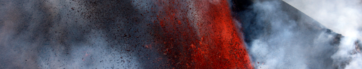
The current eruptive activity of Nyiragongo is caracterized by the presence of a persistent lava lake inside the main crater. This ~260 m-wide lava lake is often referred as the largest on Earth. A SO2-rich gas plume is continuously released from the lava lake and frequently causes important acidic rainfalls that affect vegetation, crops, human infrastructures, surface water quality and also probably human health.
The Nyiragongo lava lake is characterized by -sometimes large- level oscillations and frequent lava overflows on the lower platform of the crater (further referred as P3 ; Fig. 2), which progressively rises up to tens of metres per year. Starting from 2008, the progressive rise of the lava lake level and P3 slowed down to almost stop in 2010. During the following two years, the lava lake level oscillated through sporadic events of level fall and rise, with relatively limited overflows on P3. In April 2012, the lava lake level started a progressive decrease through sporadic level drop events. In July 2014, the mean lava lake level was measured 68 metres below P3 (Smets, 2016).

Between 29 February and 2 March 2016, the mean lava lake level came back to a closer distance to P3 and a new vent appeared east of P3, at foot of the cliff separating P2 from P3. In a couple of weeks, the lava escaping from the new vent entirely covered P3 and lavas started to flow into the lava lake (Fig. 5). Lava flows stopped in May 2016, but red glow was still visible at night at the new vent. According to the Goma Volcano Observatory (GVO), new lava flows escaping from the vent appeared from 17 August 2016. More information about the recent eruptive activity can be found in the Current Activity page.
—
5. Cited references
Allard, P., Baxter, P., Halbwachs, M., Komorowski, J.C., 2002. The January 2002 eruption of Nyiragongo volcano (Dem. Repub. Congo) and related hazards: observations and recommendations. Final report of the French-British Scientific team: submitted to the Ministry for Foreign Affairs, Paris, France, Foreign Office, London, United Kingdom and respective Embassies in Democratic Republic of Congo and Republic of Rwanda, Paris.35p. http://mhalb.pagesperso-orange.fr/kivu/pdf/concorde_sept2003.pdf (Last visited: 27 September 2015)
Baxter, P., Ancia, A., 2002. Human health and vulnerability in the Nyiragongo volcano crisis, Democratic Republic of Congo, 2002. Final report to the World Health Organisation, 39p. http://apps.who.int/disasters/repo/7828.pdf (Last visited: 27 September 2015)
Chakrabarti, R., Basu, A.R., Santo, A.P., Tedesco, D., Vaselli, O., 2009. Isotopic and geochemical evidence for a heterogeneous mantle plume origin of the Virunga volcanics, Western rift, East African Rift system. Chemical Geology 259, 273–289. doi:10.1016/j.chemgeo.2008.11.010
Demant, A., Lestrade, P., Lubala, R.T., Kampunzu, A.B., Durieux, J., 1994. Volcanological and petrological evolution of Nyiragongo volcano, Virunga volcanic field, Zaire. Bulletin of Volcanology 56, 47–61.
Durieux, J., 2004. Volcano Nyiragongo (DR Congo): Evolution of the Crater and Lava Lakes from the Discovery to the Present. Acta Vulcanologica 14-15, 137–144.
Farr, T.G., Rosen, P.A., Caro, E., Crippen, R., Duren, R., Hensley, S., Kobrick, M., Paller, M., Rodriguez, E., Roth, L., Seal, D., Shaffer, S., Shimada, J., Umland, J., Werner, M., Oskin, M., Burbank, D., Alsdorf, D., 2007. The Shuttle Radar Topography Mission. Reviews of Geophysics 45, RG2004–33. doi:10.1029/2005RG000183
Halbwachs, M., Tietze, K., Lorke, A., Mudaheranwa, C., 2002. Investigations in Lake Kivu (East Central Africa) after the Nyiragongo Eruption of January 2002, Specific study of the impact of the sub-water lava inflow on the lake stability. Final report of the international scientific team: submitted to SOLIDARITES, Aide Humanitaire d’urgence, Paris, 49 p. http://mhalb.pagesperso-orange.fr/kivu/pdf/solidarite23%20mars.pdf (Last visited: 27 September 2015)
Hertogen, J., Vanlerberghe, L., Namegabe, M., 1985. Geochemical evolution of the Nyiragongo volcano (Virunga, Western African Rift, Zaire). Bulletin of the Geological Society of Finland 57, 21–35.
Komorowski, J.-C., Tedesco, D., Kasereka, M.C., Allard, P., Papale, P., Vaselli, O., Durieux, J., Baxter, P.J., Halbwachs, M., Akumbe, M., Baluku, B., Briole, P., Ciraba, M., Dupin, J.C., Etoy, O., Garcin, D., Hamaguchi, H., Houlié, N., Kavotha, K.S., Lemarchand, A., Lockwood, J., Lukaya, N., Mavonga, G., de Michele, M., S, M., Mukambilwa, K., Munyololo, F., Newhall, C.G., Ruch, J., Yalire, M.M., Wafula, M., 2004. The January 2002 flank eruption of Nyiragongo volcano (Democratic Republic of Congo): Chronology, evidence for a tectonic rift trigger, and impact of lava flows on the city of Goma. Acta Vulcanologica 14-15, 27–62.
Le Guern, F., 1987. Mechanism of energy transfer in the lava lake of Niragongo (Zaire), 1959-1977. Journal of Volcanology and Geothermal Research 31, 17–31.
Oppenheimer, C., Lomakina, A.S., Kyle, P.R., Kingsbury, N.G., Boichu, M., 2009. Earth and Planetary Science Letters. Earth and Planetary Science Letters 284, 392–398. doi:10.1016/j.epsl.2009.04.043
Platz, T., 2002. Nyiragongo volcano, DR Congo – Mineral chemistry and Petrology. PhD Dissertation, University of Greifswald, Germany, 96p.
Platz, T., Foley, S.F., André, L., 2004. Low-pressure fractionation of the Nyiragongo volcanic rocks, Virunga Province, D.R. Congo. Journal of Volcanology and Geothermal Research 136, 269–295. doi:10.1016/j.jvolgeores.2004.05.020
Pouclet, A., 1973. L’éruption du Nyamuragira de mars à mai 1971, cône et coulées du Rugarama. IRSAC Publication spéciale 1, 1–16.
Rogers, N., James, D., Kelley, S., De Mulder, M., 1998. The generation of potassic lavas from the eastern Virunga province, Rwanda. Journal of Petrology 39, 1223–1247.
Ross, K.A., Smets, B., De Batist, M., Hilbe, M., Schmid, M., Anselmetti, F.S., 2014. Lake-level rise in the late Pleistocene and active subaquatic volcanism since the Holocene in Lake Kivu, East African Rift. Geomorphology 221, 274–285. doi:10.1016/j.geomorph.2014.05.010
Sahama, T.G., 1973. Evolution of the Nyiragongo magma. Journal of Petrology 14, 33–48.
Sahama, T.G., 1978. The Nyiragongo main cone. Annales du Musée Royal de l’Afrique Centrale 81, 88p.
Shimozuru, D., 1960. Etude sismologique du volcan Niragongo. Bulletin de l’Académie royale des Sciences d’Outre-Mer NS6 (3), 464-482.
Shimozuru, D., Berg, E., 1961. Seismological study of the Nyiragongo volcano. Bulletin de l’Académie royale des Sciences d’Outre-Mer 7, 686–712.
Shuler, A., Ekström, G., 2009. Anomalous earthquakes associated with Nyiragongo Volcano: Observations and potential mechanisms. Journal of Volcanology and Geothermal Research 181, 219–230. doi:10.1016/j.jvolgeores.2009.01.011
Smets B., 2016. Dynamics of volcanic activity in a youthful extensional setting studied by means of remote sensing and ground-based monitoring techniques: Nyiragongo and Nyamulagira volcanoes (North Kivu, D.R. Congo). PhD Thesis, Vrije Universiteit Brussel, VUBPRESS, 254pp.
Smets, B., Kervyn, M., Kervyn, F., d’Oreye, N., 2015. Spatio-temporal dynamics of eruptions in a youthful extensional setting: Insights from Nyamulagira volcano (D.R. Congo), in the western branch of the East African Rift. Earth-Science Review 150, 305 – 328. doi:10.1016/j.earscirev.2015.08.008
Smets, B., d’Oreye, N., Kervyn, M., Kervyn, F., 2016. Gas piston activity of the Nyiragongo lava lake: First insights from a Stereographic Time-Lapse Camera system. Journal of African Earth Sciences, AVCoR Special Issue. doi:10.1016/j.jafrearsci.2016.04.010
Tanaka, K., 1983. Seismicity and focal mechanism of the volcanic earthquakes in the Virunga volcanic region. In Hamaguchi, H. (Ed.), Volcanoes Nyiragongo and Nyamuragira: Geophysical aspects, The Faculty of Science, Tôhoku University, Sendai, Japan, p. 19–28.
Tazieff, H., 1975. Nyiragongo ou le volcan interdit. Flammarion, 288p.
Tedesco, D., 2004. 1995 Nyiragongo and Nyamulagira Activity in the Virunga National Park: A Volcanic Crisis. Acta Vulcanologica 14-15, 149–156.
Tedesco, D., Papale, P., Vaselli, O., Durieux, J., 2002. Report on the Activity as Consultant Volcanologists for the Nyiragongo Eruption of January 17th, 2002. Unpublished UN-OCHA Report, 48p.
Tedesco, D., Tassi, F., Papale, P., Vaselli, O., Carn, S.A., Voltaggio, M., Sawyer, G.M., Durieux, J., Kasereka, M., 2007. January 2002 volcano-tectonic eruption of Nyiragongo volcano, Democratic Republic of Congo. Journal of Geophysical Research 112. doi:10.1029/2006JB004762
Wauthier, C., Cayol, V., Kervyn, F., d’Oreye, N., 2012. Magma sources involved in the 2002 Nyiragongo eruption, as inferred from an InSAR analysis. Journal of Geophysical Research 117, B05411. doi:10.1029/2011JB008257