Category Archives: Activity Report

Nyiragongo’s lava lake activity resumes

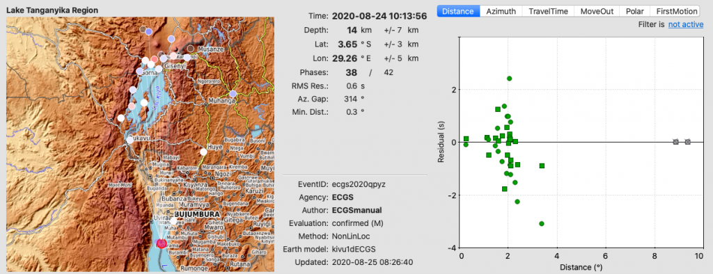
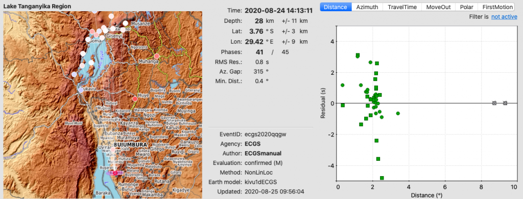
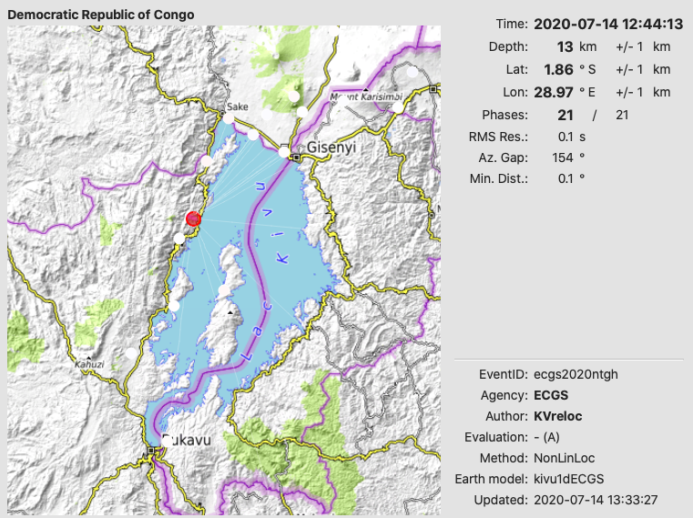
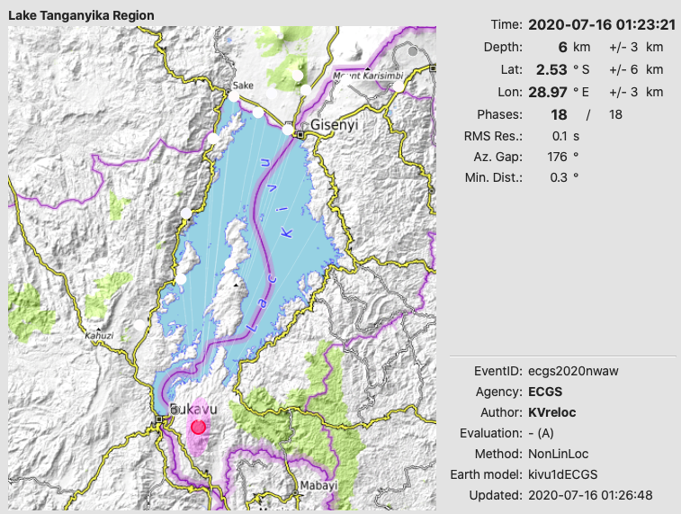
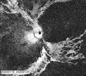
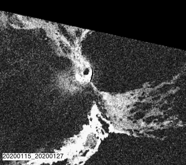
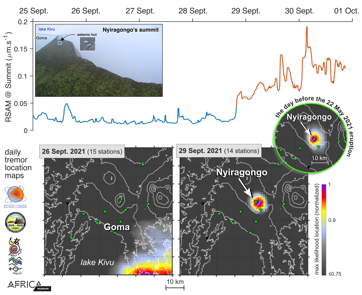
The renewal of Nyiragongo’s lava lake activity inferred from Sentinel-2 observations is confirmed by seismic measurements through the local seismic network KivuSNet (Oth et al., SRL, 2017). Top panel: 10-min RSAM (Real-time Seismic Amplitude Measurement) at the summit station (broadband station deployed in a seismic hut close to Nyiragongo’s rim, see inset) in the frequency band [0.4-1] Hz, known to be the dominant frequency content of low-frequency continuous tremor generated by the lava lake activity (before the May 2021 eruption). Bottom panels: Daily location maps for 26 September (left) and 29 September (right) of the continuous seismic tremor in the same frequency band derived from a source-scanning location algorithm using ambient noise measurements recorded at all stations across the network (see Barriere et al., GRL, 2017). No persistent low-frequency tremor originating from Nyiragongo’s crater has been detected since the flank eruption on 22 May 2021 and the associated disappearance of the lava lake. Since 28-29 September 2021, the maximum likelihood location of the ambient seismic noise indicates that a shallow seismic tremor source centered on Nyiragongo’s crater is back. 

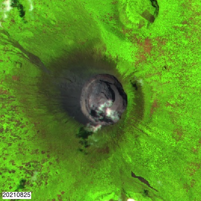
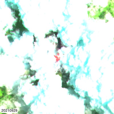
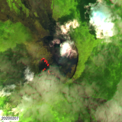
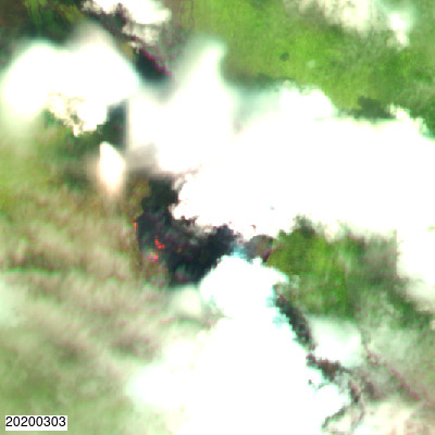
View of Nyiragongo’s crater by Sentinel 2 on the 25th August and 29th September 2021. Lava is today visible again.

Please click here to access the French version of this post on the news page of georiska.africamuseum.be

EVENTS IN NORTHERN tanganyika rift (2020-08-24)

Two close events occurred in Burundi on the 24th August 2020.

The first event occurred at 10:13:56 (UTC) with a magnitude of 4.6.

The second event occurred at 14:13:11 (UTC) with a magnitude of 5.2.

These results were obtained using KivuSnet seismic data (Oth el al., 2016). The location shown here was obtained through manual method.

Reference: – Oth et al.  (2016), KivuSNet: The First Dense Broadband Seismic Network for the Kivu Rift Region (Western Branch of East African Rift), Seismological Research Letters, doi:10.1785/0220160147/-/DC1 (Paper avialable here)

Last felt earthquake

Two earthquakes of local magnitude 4.3 and 4.4, widely felt by the local population, occurred in the past two days in the Laku Kivu region. The first one occurred on 14 July 2020 at 14:44:13 local time (12:44:13 UTC) on the western shore north of Kalehe, with an estimated depth of 13 km, while the second occurred in Rwanda, about 13 km east of the city of Bukavu, with an estimated depth of about 6 km. Both earthquakes were followed by a several recorded aftershocks.

These earthquakes were located using KivuSNet seismic data (Oth et al., 2016). The location estimates shown in the figures below were obtained by automatic processing through the SeisComP software package.

These earthquakes are normal occurrences in the tectonic context of the Kivu Rift region and are as such not indicative of any changes in the volcanic activity at Nyiragongo and Nyamulagira volcanoes.

Reference: – Oth et al.  (2016), KivuSNet: The First Dense Broadband Seismic Network for the Kivu Rift Region (Western Branch of East African Rift), Seismological Research Letters, doi:10.1785/0220160147/-/DC1

(Paper avialable here)

[DISPLAY_ULTIMATE_SOCIAL_ICONS] 

New lava flow in the crater at Nyamulagira

ESA Sentinel 1 and 2 captured a new lava flow inside the crater at Nyamulagira since January 27-31 2020.

The flow originates from the pit crater located in the NW part of the main crater and fills the large trough located to the SW part of the crater. This new flow is however not related to a recent change of activity at Nyamulagira as attested by the absence of modification in the seismicity, degassing or ground deformation patterns. It is only the result of the overflow of the pit crater that started filling up following the last eruption (see background section below). 

Recent Sentinel-2 images (bands 11 8 4) showing the lava flow.

Animated gif of coherence from Sentinel-1 radar interferometry. When the lava flows, coherence is lost, changing from white to black colour along its path.

Coherence Ascending
Coherence Descending

Background : At the end of the last eruption at Nyamulagira (November 2011 to April 2012), the pit crater progressively collapsed during more that a year. Lava fountains appeared at the bottom in April 2014 (Smets et al. 2014), ultimately forming a lava lake. Since then, and mostly since beginning of 2018, the lava lake level rose, filling the crater progressively. 

Ref: Smets, B., N. d’Oreye, and F. Kervyn (2014), Toward Another Lava Lake in the Virunga Volcanic Field? EOS Trans. AGU.

Last felt earthquake

Last felt earthquake (2019.04.19):

A felt earthquake of local magnitude 4.3 occurred on 19 April 2019 at 10:56 local time (8:56 UTC) in the Bukavu-Kavumu region.

Event Location

These results were obtained using KivuSnet seismic data (Oth el al., 2016). The location shown here was obtained through automatic processing.

Reference:
– Oth et al.  (2016), KivuSNet: The First Dense Broadband Seismic Network for the Kivu Rift Region (Western Branch of East African Rift), Seismological Research Letters, doi:10.1785/0220160147/-/DC1