Page Content
- Lava flows
- Volcanic gas
- Mazuku
- Ash and Tephra
- Phreatic and phreatomagmatic eruptions
- Landslides and Mud Flows
- Earthquakes
- Dissolved Gases in Lake Kivu
- Cited References
_______________________________
1. Lava Flows
The flank eruptions of Nyiragongo are very dangerous for the population leaving at foot of the volcano. The low-viscous lavas of the Nyiragongo create very fast moving lava flows, which are able to reach tens of km/h on the volcano’s flanks. In 1977 and 2002 these lava flows destroyed villages and a part of the city of Goma (today ~1 000 000 inhabitants) within a few hours only.
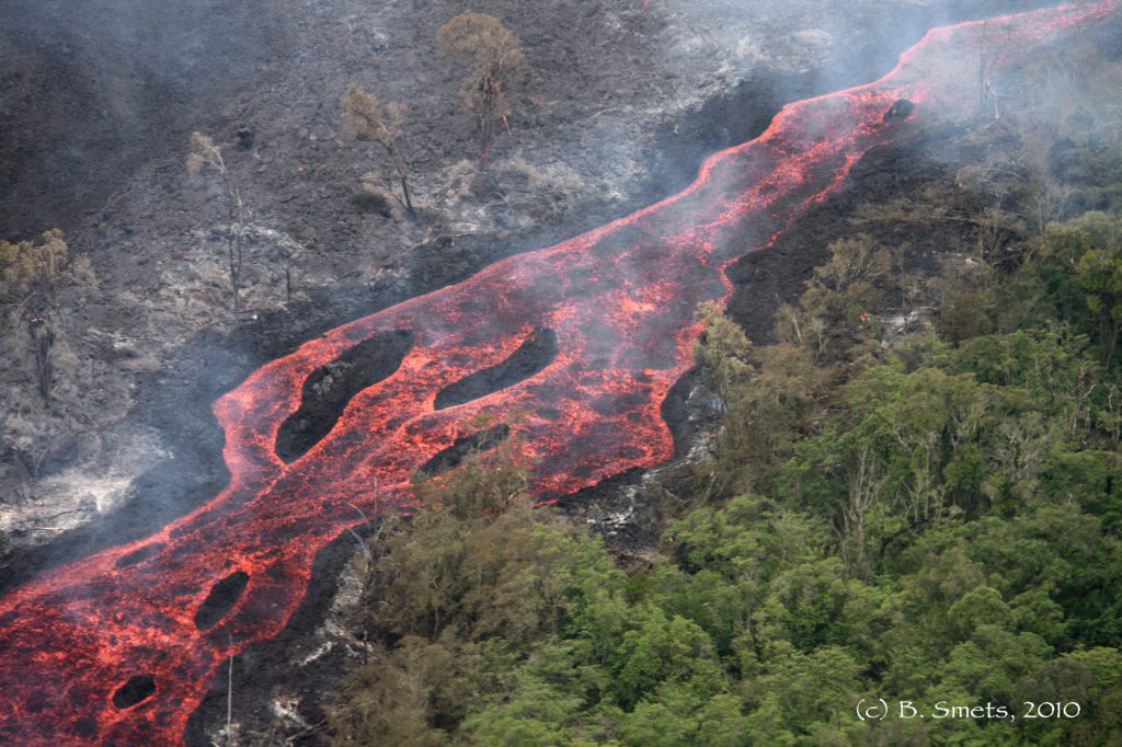
The lava flow field of Nyamulagira covers more than 1100 km2 and is mainly located inside the Virunga National Park (VNP), an endangered UNESCO World Heritage. Nyamulagira flank eruptions always affect the VNP by burning several hundreds hectares of the protected forest. Since the 1938-40 eruption, flank eruptions have dominated the Nyamulagira activity. As vegetation takes time to colonize fresh lavas, the lava flows of these eruptions have progressively reduced the area occupied by the dense forest during the last 70 years. When distal eruptions* occur, the lava flows can reach roads, crops and urban areas. These lava flows mainly cause material damages and are usually not a lethal hazard for the population.
* We call here a “distal eruption” an eruptive event that occurs more than 9 km away from the Nyamulagira main edifice.
—
2. Volcanic Gas
The permanent SO2-rich gas plume emanating from Nyiragongo triggers acidic rainfalls that affect vegetation, crops, human infrastructures, surface water quality and human health.
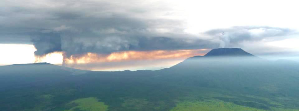
Each eruption of Nyamulagira produces a huge volcanic plume that seriously affects the surrounding area. Each volcanic plume of Nyamulagira also contains large amounts of gases, especially CO2, SO2 and other acid gases. According to the measurements of the Total Ozone Mapping Spectrometer (TOMS) reported by Bluth and Carn (2008), Nyamulagira has been the world’s largest source of volcanogenic SO2 released to the atmosphere since 1979, accounting for a cumulated emission of ~25 Mt of SO2 between 1979 and 2005. These volcanic gas plumes are at the origin of sometimes-important acid rainfalls. In the close vicinity of the active vent(s), SO2 and acid gases seriously affect the vegetation and pollute river waters.
—
3. Mazuku
The word “Mazuku” comes from Kinyabwisha, a dialect from Rwanda, and indicates areas where both human and animals mysteriously die during the night (Verschuren, 1965). In the field, these areas were found to be dry gas vents that correspond to depressions where carbon dioxide, being heavier than air, accumulates by gravity in often lethal concentration (15 to >80 %vol. of CO2). According to isotopic analyses, CO2 originates from the Upper Mantle (Vaselli et al., 2004). Mazuku kill humans and animals every year, though this phenomenon is known since a long time in the Virunga Volcanic Province.
Mazuku in inhabited areas are located along the northern shore of Lake Kivu, between Sake and Goma. Due to the exponential demographic growth in this area, mazuku represent an increasing hazard that seriously threaten humans, especially refugees and new inhabitants who, unlike the local population, are not aware of the danger. Mazuku kill tens of people every year, which make them the most important natural hazard for the area in terms of human loss.
- Preferential location
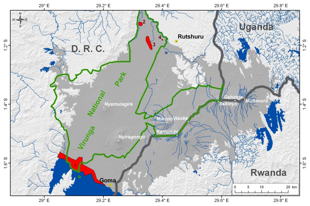
Mazuku in the Sake-Goma area are usually located within a 3km -wide strip along the shoreline of Lake Kivu, which corresponds to the area where volcanic cones have a phreatic or phreatomagmatic origin (Fig. 3). This observation suggests a possible link between mazuku and a hydrothermal system and/or groundwater (Capaccioni et al., 2004 ; Vaselli et al., 2004).
Mazuku often appear at foot of lava flows where the stacking of lava flows creates morphological depressions. Depressions where gas accumulates can also be formed by collapsed lava tunnels, or open cracks (open faults, cooling fractures, etc.) that provide a preferential access to the surface for gas and a depression for gas accumulation.
The spatial distribution of mazuku also suggests a possible link with large structures such as volcanic fractures and faults, but it is not always well evidenced due to the lava flow accumulation that usually hides those structures (Smets et al., 2010).
- Presence of Radon
Radon (222Rn) is also detected inside mazuku. Radon is a radioactive noble gas that originates from radium (226Ra), a member of the natural 238U decay series. Uranium and radium concentrations vary with the specific site and geological material. Radon migrates through pores in soil, fractures in rocks and along weak zones like shears, faults, thrust, …. As radon concentrations are extremely small (typically 1/10-17), radon needs a carrier gas (soil-air, CO2, CH4 …) for transport over long distances.
- Gas dynamics
Field observations and measurements show that atmospheric pressure, wind and rainfall can strongly influence gas concentration in mazuku. These meteorological parameters can modify the hazard level of a given mazuku. Consequently, the human perception of the risk in a mazuku varies accordingly.
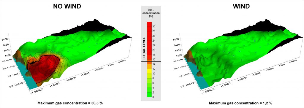
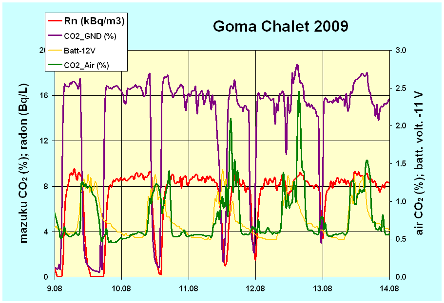
First datasets from the continuous gas flux monitoring in the mazuku “Le Chalet” show daily variations in gas concentrations measured in the subsurface and in open air of the mazuku. Data also reveal that solar irradiance is another parameter that influences atmospheric CO2 concentrations. The study of all variations in gas concentration is still in progress and no link with volcanic activity has been established so far.
—
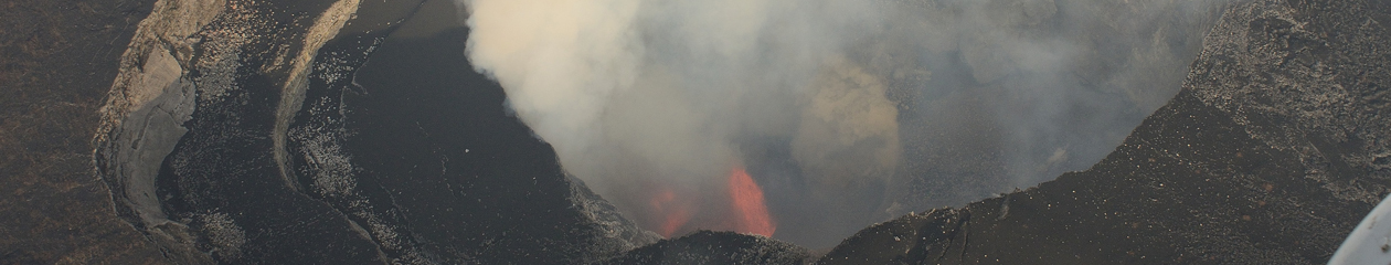
4. Ash and Tephra
Each eruption of Nyamulagira produces a huge volcanic plume that seriously affects the surrounding area.
At the early stage of the eruptions, the plume contains high amounts of ash, scoriae, bombs and pelee’s hairs. Scoriae and bombs usually fall down maximum 2-3 km far from the eruptive vent while ash and pelee’s hairs can be found tens of kilometers away from the eruptive vent(s). Eruptions generally take place within the National Park, but those pyroclastic deposits can cause problems to the local population leaving outside of the park, mainly by affecting crops and livestock.
—
5. Phreatic and phreatomagmatic eruptions
Several pre-historic small-scale phreatomagmatic volcanoes lie along Lake Kivu’s northern shoreline, highlighting the potential for explosive magma-water interaction. These cones were recently studied by Poppe et al. (in press), who estimate that at least 16 phreatomagmatic or phreatic eruptions occurred in the Holocene, during which Lake Kivu rose to its current water level. Radiocarbon dates of paleosols in volcanic tuffs range between ~2,500 and ~150 cal yr BP, and suggest centennial- to millenial-scale recurrence of phreatomagmatic activity. A vast part of the currently urbanized zone on the northern shoreline of Lake Kivu was most likely impacted by volcaniclastic activity, including pyroclastic density current events, during the Late Holocene, highlighting the need to consider explosive magma-water interaction as a potential scenario in future risk assessments.
—
6. Landslides and Mud Flows
Throughout the Kivu basin region, landslides represent the most severe hazard at local scale. The widespread distribution of these mass movements is shown by the newly developed on-line database “The natural hazard database for Central Africa”. In the study area, landslides can be triggered both by climatic events (strong rainfall) as well as seismic or volcanic (mudflows) activity, or even by combined effects. The potential impact of these landslides is increased by anthropogenic factors, such as deforestation for example. Moreover, it has been found that the frequency and magnitude of mass movements and their effects in urban areas in Central Africa (such as Kinshasa, Bukavu, Uvira, Mbuji-Mayi, Butembo and Bujumbura) are much greater than what can be expected if only natural factors are taken into consideration. In Bukavu, for instance, both the rift escarpments and Lake Kivu limit the urban expansion. Therefore, the population is forced to settle in increasingly unsuitable areas, resulting in numerous examples of major roads or houses constructed on slopes affected by landslides or rock falls.
In the Virunga Volcanic Province, strong rainfalls sometimes trigger torrential events on the volcano flanks, especially along the flanks of the central and eastern volcanoes of the volcanic province. The main edifices of dormant volcanoes in the Virunga volcanic chain are indeed cut by deep gullies of dense temporary hydrographical networks (Jost, 1987). The triggered torrents are able to mobilize large amounts of unconsolidated deposits and develop in fast and devastating mudflows. Such event is not unusual in the Virunga region and occurred several times during the last Century. The last lethal mud flow event occurred in May 2010 and affected the village of Kibiriga, in DR Congo (click here for more information).
—
7. Earthquakes
The Kivu Basin region is the most densely populated region of the rift where a concentration of geohazards is also observed. The western branch of the East African Rift, where the Kivu basin is located, is characterized by a strong seismicity as testified by the recorded largest magnitude earthquakes of Africa in 1910 (M 7.3 western Tanzania), 1990 (M 7.0, South Sudan), 1992 (M 7.0, eastern DRC) and 2005 (M 6.8, eastern DRC). A preliminary catalogue compiled by Herrinckx (1959) lists about 800 “felt seisms” between 1909 and 1954 in Congo, Rwanda and Burundi. More recently, moderate magnitude earthquakes have hit the Kivu basin area and caused important damages and casualties. One of the last catastrophic earthquakes (M 5.9) was recorded in the Bukavu-Cyangugu area in February 2008: 38 persons died (d’Oreye et al., 2010). Due to the demographic increase more and more people and infrastructure are exposed to the seismic risk in this region. A new earthquake similar to the Rukwa 1910 earthquake (M 7.3) would have catastrophic consequences.
Examples of seismic crises in the Kivu rift region:
—
8. Dissolved gases in Lake Kivu
Lake Kivu is 485m deep and is characterized at depth by a permanent layer of water which is not affected by seasonal convection. In these deep waters, the pressure and temperature conditions allow the storage of huge amounts of dissolved gas corresponding to methane (CH4) and carbon dioxide (CO2). The volume of dissolved gas is estimated to 300 km3 for CO2 and 60 km3 for CH4 (Schmid et al., 2005; Pasche et al., 2011). The main origin of these gases are mantellic for CO2 and biogenic for CH4 (Tietze et al., 1980; Pasche et al. 2011).
The hazard commonly mentioned for Lake Kivu is a mixing of the deep gas-rich water layer with surface waters, which would trigger a lake overturn (or limnic eruption) and the release of the dissolved gases in the atmosphere, killing, by asphyxia, humans and animals in the vicinity of the lake. Such event already occurred in 1986, at Lake Nyos (Cameroon), causing the death of livestock near the lake (Allard et al., 2002). However, Lake Kivu contains ~2000 times more gas and would affect a more densely populated area with more than 2 millions persons leaving in close vicinity of the lake. Fortunately, the dissolved gas content in Lake Kivu does not reach saturation yet, as it was the case at Lake Nyos before the limnic eruption.
The limnic eruption hazard at Lake Kivu is highly debated in the scientific community working in the Lake Kivu region, especially since the Rwandese government developed a program for the exploitation of the dissolved methane for energy production. The main scientific discussions are focused on the potential triggering factors of a limnic eruption (i.e., earthquake, large underwater landslide, underwater volcanic eruption) and the environmental impacts of gas extraction.
—
9. Cited references
Allard, P., Baxter, P., Halbwachs, M., Komorowski, J.C., 2002. The January 2002 eruption of Nyiragongo volcano (Dem. Repub. Congo) and related hazards: observations and recommendations. Final report of the French-British Scientific team: submitted to the Ministry for Foreign Affairs, Paris, France, Foreign Office, London, United Kingdom and respective Embassies in Democratic Republic of Congo and Republic of Rwanda, Paris.35p. http://mhalb.pagesperso-orange.fr/kivu/pdf/concorde_sept2003.pdf (Last visited: 27 September 2015)
Bluth, G.J.S., Carn, S.A., 2008. Exceptional sulfur degassing from Nyamuragira volcano, 1979-2005. International Journal of Remote Sensing 29, 6667–6685.
Capaccioni, B., Vaselli, O., Santo, A.P., Yalire, M.M., 2004. Monogenic and polygenic volcanoes in the area between the Nyiragongo summit crater and the Lake Kivu shoreline. Acta Vulcanologica 14-15, 129–136.
d’Oreye, N., González, P.J., Shuler, A., Oth, A., Bagalwa, L., Ekström, G., Kavotha, D., Kervyn, F., Lucas, C., Lukaya, F., Osodundu, E., Wauthier, C., Fernández, J., 2010. Source parameters of the 2008 Bukavu-Cyangugu earthquake estimated from InSAR and teleseismic data. Geophysical Journal International 184, 934–948. doi:10.1111/j.1365-246X.2010.04899.x
Herrinckx, P., 1959. Séismicité du Congo belge. Acad. Roy. Sci. Col. Cl. Sci. Nat. Méd. Mém. in8° nouv. série 9 (5), 1-55.
Jost, C., 1987. Contraintes d’aménagements en région volcanique tropicale : La chaîne des Birunga au Rwanda. Université Louis Pasteur, Strasbourg 1. 283 p.
Pasche, N., Schmid, M., Vazquez, F., Schubert, C.J., Wüest, A., Kessler, J.D., Pack, M.A., Reeburgh, W.S., Bürgmann, H. (2011). Methane sources and sinks in Lake Kivu. Journal of Geophysical Research: Biogeosciences, 116(G3).
Poppe, S., Smets, B., Fontijn, K., Rukeza, M.B., Migabo, A.F., Milungu, A.K., Namogo, D.B., Kervyn F., Kervyn M., In Press. Holocene phreatomagmatic eruptions alongside the densely populated northern shoreline of Lake Kivu, East-African Rift: timing and hazard implications. Bulletin of Volcanology.
Smets, B., Tedesco, D., Kervyn, F., Kies, A., Vaselli, O., Yalire, M.M., 2010. Dry gas vents (“mazuku”) in Goma region (North-Kivu, Democratic Republic of Congo): Formation and risk assessment. Journal of African Earth Sciences 58, 787–798. doi:10.1016/j.jafrearsci.2010.04.008.
Vaselli, O., Capaccioni, B., Tedesco, D., Tassi, F., Yalire, M.M., Kasereka, M.C., 2004. The “evil’s winds” (mazukus) at Nyiragongo volcano (Democratic Republic of Congo). Acta Vulcanologica 14-15, 123–128.
Verschuren, J., 1965. Un facteur de mortalité mal connu, l’asphyxie par gaz toxiques naturels au Parc National Albert, Congo. La Terre et la Vie 3, 215–237.